

“Ask the desert how much it needs the rain.” – Rinku Dutta
Why DO deserts miss the rain? The answer lies within the relationship between orographic precipitation and rain shadows. Come with me, let’s discuss…
Mountains and mountain ranges have two sides: a windward side and a leeward side. Prevailing winds travel across the ocean and up a mountains windward side. The winds descend down the leeward side.

When talking about meteorology, orographic precipitation occurs when moist air is forced upwards over rising terrain, such as a mountain. When the air rises and cools to a lower temperature, orographic clouds start to form creating a source of precipitation. Most of this falls upwind of a given mountain ridge. When these air masses are forced over high topography it is common for a concentrated amount of rainfall on the windward side of mountains. Windward climates are wet and cool.

The leeward side of mountain ranges receive a considerably lower amount of precipitation than the windward side. The result of which is called a rain shadow. Rain shadows are patches of land that are become a desert because mountain or mountain ranges have blocked off the patches of land’s ability to grow plants. Climatologically, rain shadows are warm and dry areas. When an air mass moves from a low elevation to a higher elevation, the air expands and cools. Cool air cannot contain the moisture of warm air so by the time air rises up the windward side, it has been stripped of most of its moisture. The dry warm air travels down the leeward side where it compresses and causes clouds to dissipate which results in less rainfall.

Image: NOAA Climate.gov
The rain shadow caused by orographic precipitation is important in understanding the geography of North America because it explains the cause and formation of the deserts in North America.
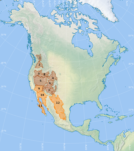
Cold deserts:
1. Thompson-Okanagan Plateau
2. Columbia Basin
3. Northern Basin and Range
4. Wyoming Basin
5. Central Basin and Range
6. Colorado Plateaus
7. Arizona/New Mexico Plateau
8. Snake River Plain
Hot deserts:
9. Mojave Basin and Range
10. Sonoran Desert
11. Baja Californian Desert
12. Chihuahuan Desert
Covering 200,000 square miles, the Great Basin Desert is the second-largest desert in North America after the Chihuahuan. The Great Basin Desert reaches from the Southern Cascades and Sierra Nevada (source of the rain shadow that forms it). The Great Basin Desert averages 6 to 12 inches of rain annually while Sierra Nevada receives 30 to 80 inches. The leeward side of the Sierra Nevada range receives 20-40 inches while the windward side can see 70-80 inches of precipitation.


Reblogged this on North American Travels and commented:
Oh yes
Like the deserts… https://youtu.be/i1iAoWK1rS8
LikeLiked by 1 person
I was thrilled to see the quote that reminded me of the song! I hope you don’t mind but I am gonna reblog this and add the lyrics 😀 I know there are other versions, but I’m posting the one I like 😉
LikeLiked by 2 people
That’s fine. Thank you!
LikeLiked by 1 person
I have experience with the plateaus of middle Tennessee and of western PA and I wonder if the fact that these are composed of so much limestone affects some of the cycle. I mean, I know that the volume of water moves quickly through the limestone without the erosion one sees in the steeper terrain, but I have always thought it interesting how that system is so very different.
LikeLike